Berkas:Windmills D1-D4 (Thornton Bank).jpg
Loncat ke navigasi
Loncat ke pencarian
Ukuran pratayang ini: 388 × 600 piksel. Resolusi lainnya: 155 × 240 piksel | 310 × 480 piksel | 496 × 768 piksel | 662 × 1.024 piksel | 1.324 × 2.048 piksel | 2.676 × 4.138 piksel.
Ukuran asli (2.676 × 4.138 piksel, ukuran berkas: 5,81 MB, tipe MIME: image/jpeg)
.jpg)
Ringkasan
| Lokasi kamera | | Lihat gambar ini dan gambar di sekitarnya di: OpenStreetMap |
|---|
.jpg¶ms=051.545500_N_0002.929850_E_globe:Earth_type:camera__&language=id)
| Fotografer |
Hans Hillewaert |
| Deskripsi |
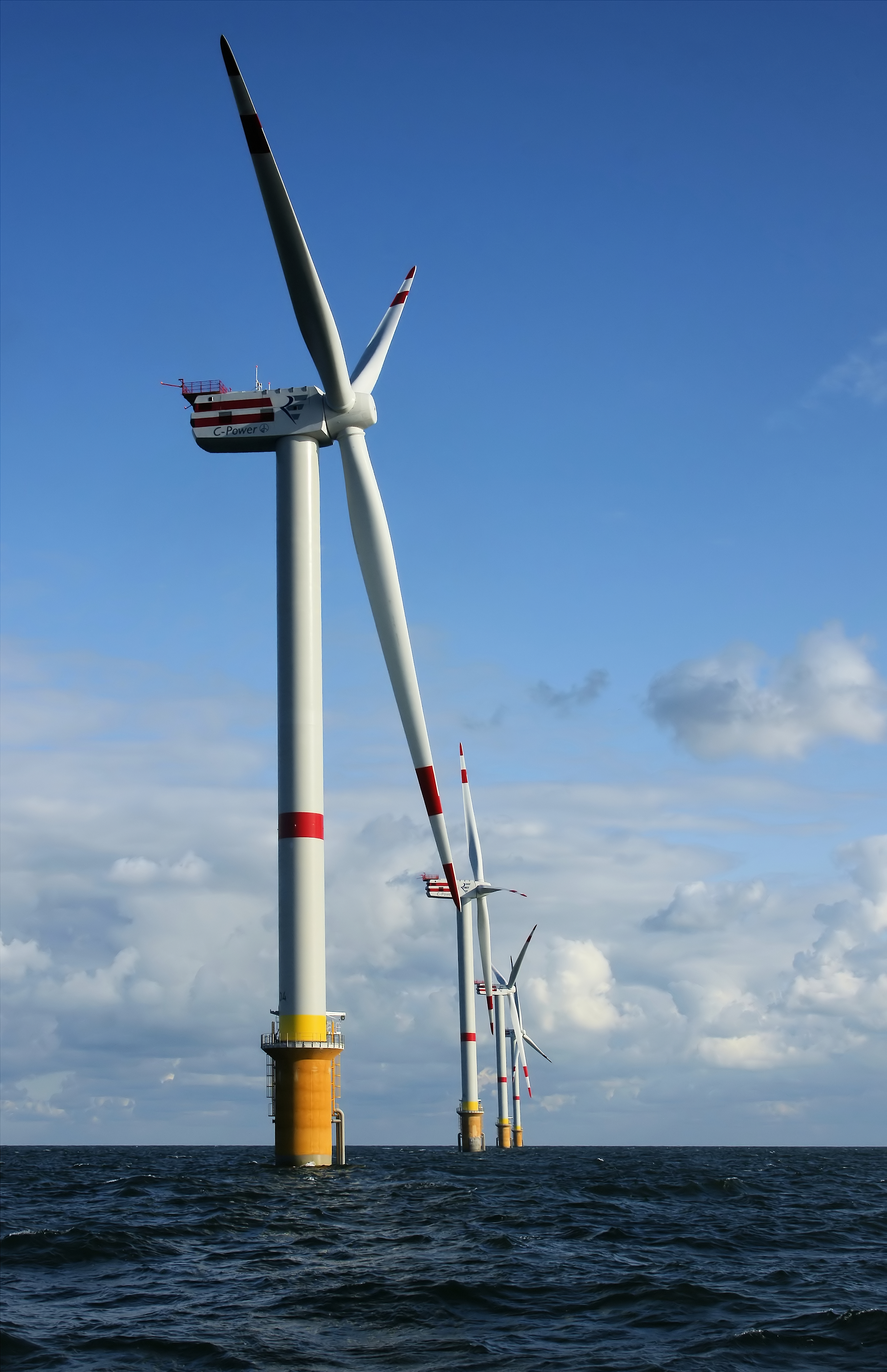
العربية: عنفات رياح حديثة الإنشاء، تُرى بدايةً من العنفة D4 (الأقرب) إلى العنفة D1، على ضفة ثورنتون، الواقعة على بُعد 28 كلم عن اليابسة، في القسم البلجيكي من بحر الشمال. يبلغ ارتفاع العنفة الواحدة انطلاقًا من سطح الماء 157 مترًا (+ مراوحها)، وعند احتساب ارتفاعها الكامل انطلاقًا من قاع البحر فإنها تصل إلى 184 مترًا.
English: Newly constructed windmills D4 (nearest) to D1 on the Thornton Bank, 28 km off shore, on the Belgian part of the North Sea. The windmills are 157 m (+TAW) high, 184 m above the sea bottom.
Français : Éoliennes D4 (au premier plan) à D1 (en arrière plan) ; nouvellement construites sur le banc Thornton, à 28 kilomètres de la côte belge, dans la Mer du Nord. Ces éoliennes mesurent 157 m de haut (plus les ailes), soit 184m au dessus du fond marin. |
| Tanggal | 29 September 2008 |
| Sumber | Karya sendiri |
| Izin (Menggunakan kembali berkas ini) |
Berkas ini dilisensikan di bawah lisensi Creative Commons Atribusi-Berbagi Serupa 4.0 Internasional. Atribusi: © Hans Hillewaert
|
| Other licenses | More (4100+) and new images on : High resolution files on request. . |
| Atribusi (required by the license) | © Hans Hillewaert / |
|
.jpg)
.jpg)
.jpg)
.jpg)
.jpg)
Gambar ini telah dipilih sebagai gambar hari ini di Wikimedia Commons pada 16 Maret 2012. Gambar tersebut memiliki keterangan berikut: English: Newly constructed windmills on the Thornton Bank, 28 km off shore, on the Belgian part of the North Sea. The windmills are 157 m high, 184 m above the sea bottom. Bahasa lain:
Dansk: Nyopførte vindmøller på Thornton Bank, 28 km uden for kysten i den belgiske del af Nordsøen. Møllerne er 157 m.o.h., 184 m høje fra havbunden. English: Newly constructed windmills on the Thornton Bank, 28 km off shore, on the Belgian part of the North Sea. The windmills are 157 m high, 184 m above the sea bottom. Español: Generadores eólicos recién construidos en Thorntonbank, 28 km mar adentro, en la parte belga del Mar del Norte. Los molinos tienen 157 m de alto, 184 m desde el fondo marino. Français : Éoliennes nouvellement construites sur le banc Thornton, à 28 kilomètres de la côte belge, dans la Mer du Nord. Ces éoliennes mesurent 157 m de haut (plus les ailes), soit 184 m au dessus du fond marin. Italiano: Mulini a vento sul Thornton Bank, 28 km al largo delle coste belghe nel Mare del Nord in acque profonde da 12 a 27 metri. Nederlands: Nieuw geconstrueerde windmolens op de Thorntonbank 28 kilometer offshore in het Belgische deel van de Noordzee. De windmolens zijn 157 meter (+TAW) hoog en bevinden zich 184 meter boven de zeebodem. Polski: Turbiny wiatrowe na farmie Thornton Bank na Morzu Północnym, oddalone 28 km od belgijskiego brzegu. Wiatraki mają 157 m wysokości (184 m od dna morskiego). Македонски: Новоизградени ветерни турбини на гребенот Торнтонбанк, 28 км од белгискиот брег на Северното Море. Українська: Вітрогенератори (від D4 (найближчий) до D1, всього їх шість) Вітряної електростанції на обмілині Торнтон (фр. Parc éolien de Thorntonbank) за 28 км від узбережжя в бельгійських територіальних водах Північного моря. Висота вітрогенератора, враховуючи довжину лопаті — 157 м, загальна висота над дном моря — 184 м. 日本語: 北海ベルギー領の沖合28キロメートル洋上に建設中のソーントンバンク風力発電所。風車は高さ157メートルで、海底から184メートル上にある。 中文: 北海比利时桑顿海滩新建的风车,风车高度157米,从海底计算高度为184米。 |
Riwayat berkas
Klik pada tanggal/waktu untuk melihat berkas ini pada saat tersebut.
| Tanggal/Waktu | Miniatur | Dimensi | Pengguna | Komentar | |
|---|---|---|---|---|---|
| terkini | 29 Maret 2009 09.39 | | 2.676 × 4.138 (5,81 MB) | wikimediacommons>Lycaon | {{location dec|51.54550|2.92985}} {{Information |Description={{en|Newly constructed windmills D4 (nearest) to D1 on the Thornton Bank, 28 km off shore, on the Belgian part of the North Sea. The windmills are 157 m (+TAW) high, 184 m above the sea bottom.< |
Penggunaan berkas
Halaman berikut menggunakan berkas ini:
.jpg)